IMAGE
French Language Speakers Map of New England Item Info
- Title:
- French Language Speakers Map of New England
- Creator:
- Madeleine Giguere
- Date Created:
- 1980
- Description:
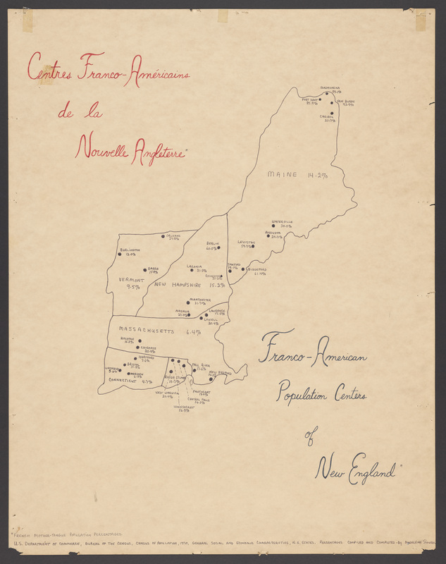
- Madeleine Giguere created this map using data gleaned from the 1970 census. The census included a question about languages spoken in the home, and this map was created using information from those who listed French as their mother tongue. As you can see, Giguere highlighted cities as population centers even if they contained only 5% French speakers. Another interesting observation is that the closer to Canada you get, the higher the numbers of French speakers are. For example: Connecticut includes the lowest numbers, Massachusetts slightly more than CT, and New Hampshire slightly more than MA, and Maine with the highest number French language speakers found in the Aroostook county towns of Fort Kent, Madawaska and Van Buren.
- Subjects:
- hand drawn, map, sociology, French language, New England
- Source:
- Madeleine Giguere Papers
- Type:
- Image;StillImage
- Format:
- image/jpeg
Source
- Preferred Citation:
- "French Language Speakers Map of New England", Madeleine Giguere Papers, Franco-American Collection, University of Southern Maine
- Repository Link:
- https://digitalcommons.usm.maine.edu/giguere-map/1
Rights
- Rights:
- In copyright - Educational use permitted
- Standardized Rights:
- https://rightsstatements.org/vocab/InC-EDU/1.0/

